Urban transport systems are complex, dynamic, and deeply human. To plan them effectively, we need models that capture how people actually move, not just how traffic flows. Over the past few months, I’ve been building such a model for Wellington using MATSim, an open-source Agent-Based Model (ABM) platform designed for large-scale transport simulation.
This work brings together multiple data streams, Census, Household Travel Survey (HTS), OpenStreetMap (OSM), and GTFS, to create a fully integrated model of how people travel across the Wellington region.
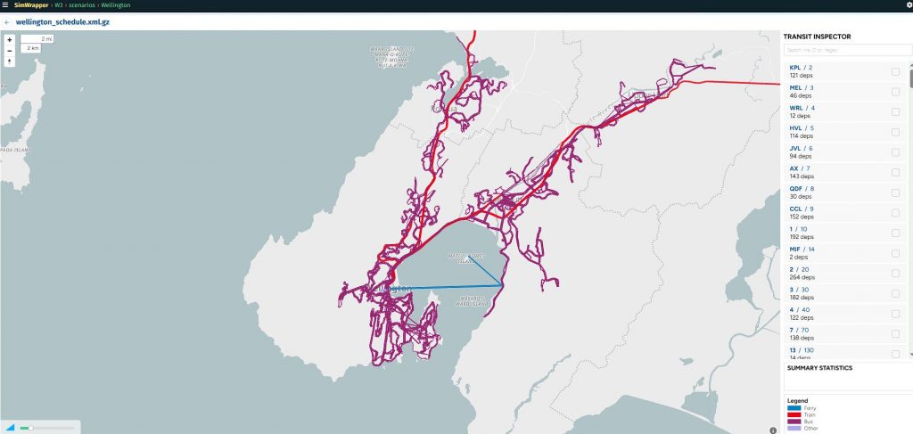
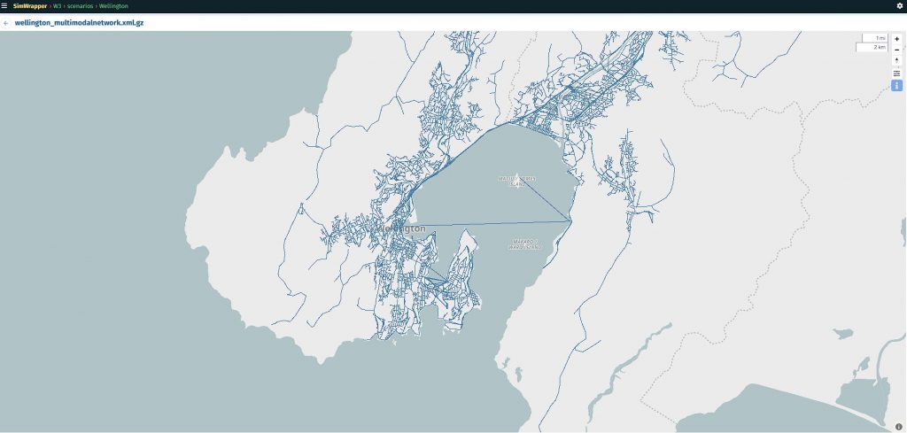
Step 1: Building the Multimodal Network
In an earlier LinkedIn post, I detailed how to create a MATSim-ready transport network using data from OSM (for roads and walking/cycling infrastructure) and GTFS (for public transport services).
By processing these layers together, we obtain a multimodal network that allows agents to choose between driving, public transport, cycling, or walking — reflecting real-world options.
Key outputs include:
- A detailed digital representation of Wellington’s roads, bus routes, and rail lines.
- Mode-specific network attributes like speed, capacity, and travel times.
- Integration between the public and private transport systems, ensuring realistic mode switching.
This foundation enables MATSim to simulate how thousands of individual trips interact across modes and time periods.
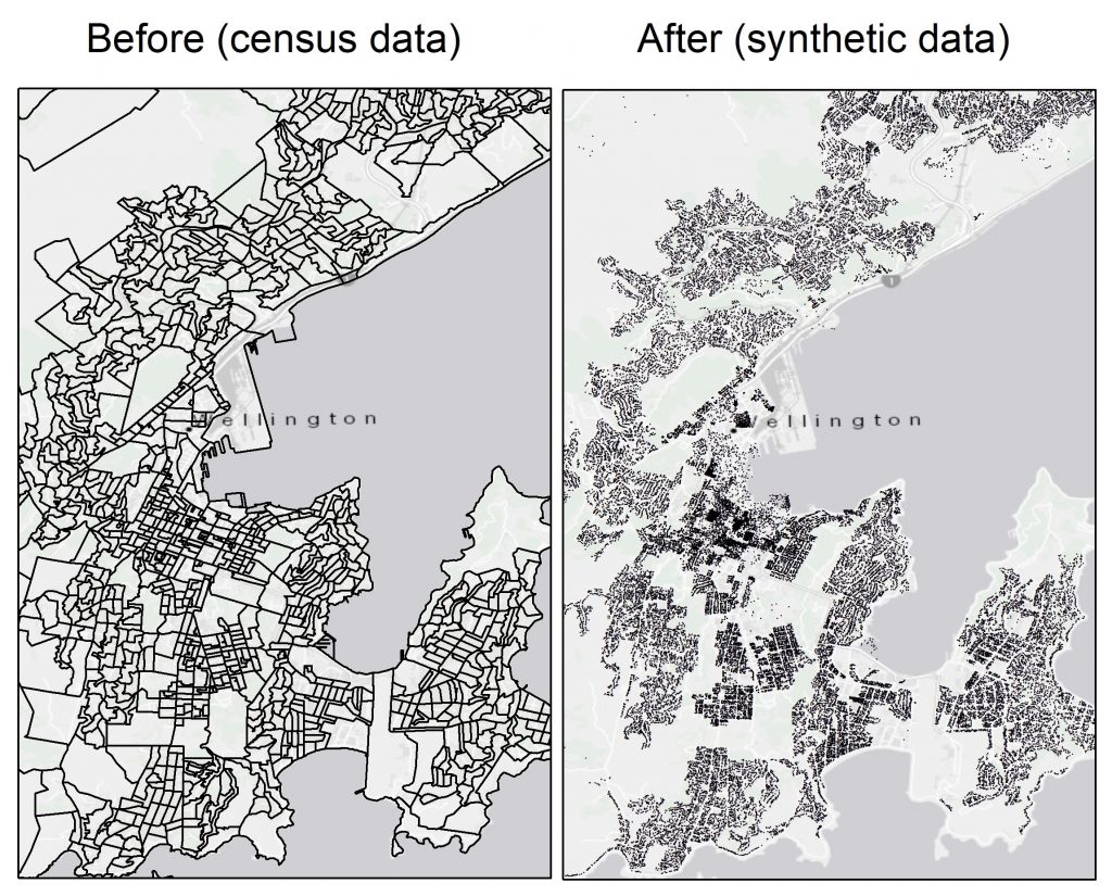
Step 2: Creating a Synthetic Population
To simulate realistic travel demand, we need people, but without compromising privacy.
That’s where synthetic data comes in. Using PopulationSim, I generated a synthetic population that mirrors Wellington’s demographics based on Census and HTS data.
Each synthetic person has attributes such as:
- Age, occupation, household, and home location
- Daily activity patterns derived from travel survey distributions
To make the dataset spatially rich, I extended PopulationSim to assign each household to a random residential location within its census zone. This step bridges demographic realism with spatial fidelity, allowing each agent to “live” somewhere specific within the model area.
Synthetic data allows us to:
✅ Preserve privacy — no real individuals are represented
✅ Explore “what-if” scenarios safely
✅ Enable open, reproducible research
You can view or download the Wellington Synthetic Population (v1.0) here: Download Link
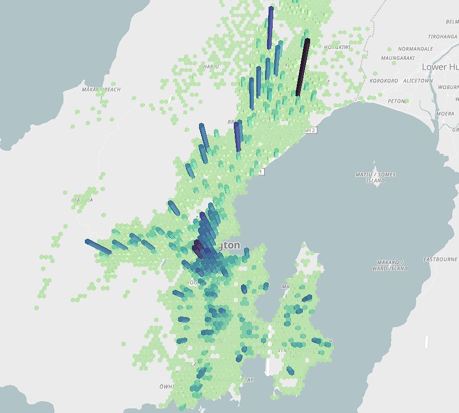
Step 3: Running the Agent-Based Model
With the network and population in place, the final step was to run the MATSim simulation. A city-scale virtual experiment that models how synthetic agents travel through the network during a typical day.
Each agent plans a series of activities (e.g., home → work → shopping → home), and MATSim iteratively adjusts routes and mode choices until an equilibrium is reached. Where no agent can improve their travel time by unilaterally changing behaviour.
The model provides insights such as:
- Mode shares (car, PT, walking, cycling)
- Network congestion hotspots
- Public transport load factors
- Impacts of policy changes — e.g., new bus routes, congestion pricing, or cycling investments
Because every trip is simulated individually, the model can capture subtle effects like local bottlenecks, mode shifts, and time-of-day congestion.
Why This Matters
Agent-based modelling bridges the gap between data and decisions.
By combining open data sources, synthetic populations, and simulation technology, we can:
- Evaluate transport interventions before implementation
- Test policy trade-offs with behavioural realism
- Support evidence-based investment decisions
As cities like Wellington continue to grow and evolve, these tools empower planners, researchers, and policymakers to explore the consequences of change safely, quickly, and transparently.
What’s Next
In future work, I’ll focus on:
- Calibration and validation using observed travel counts and smartcard data
- Scenario testing (e.g., mode shift targets, urban intensification)
- Visual analytics to communicate results interactively
If you’re interested in applying agent-based modelling to your region or project, feel free to reach out. I’d be happy to discuss how these tools can help support data-driven transport planning.
You can reach me at saeid.adli@spatialeconomics.co.nz or contact me directly on 022 344 3551 to discuss potential collaborations or data-driven transport projects.
Hashtags:
#TransportModeling #AgentBasedModels #MATSim #SyntheticData #OpenData #Wellington #TransportPlanning #DataScience