
Introduction
Auckland Transport’s road pricing scheme aims to address the city’s growing congestion issues. While the scheme’s economic objectives are clear, its social implications, particularly on lower socioeconomic communities, warrant closer examination. Two weeks ago, I wrote a LinkedIn post highlighting areas where individuals with lower socioeconomic status will face higher travel costs due to the proposed road pricing. This blog post delves into the methodology, findings, and broader implications of this analysis.
Overview of Auckland Transport’s Road Pricing Scheme
Auckland’s road pricing scheme, also known as Time of Use Charging, is designed to manage congestion by charging drivers for using specific road segments during peak times. The primary goals are to reduce traffic congestion, improve travel times, and encourage the use of public transport and other sustainable modes of travel.
This initiative builds on the findings of the Auckland Transport Alignment Project (ATAP), which outlined a 30-year vision for Auckland’s transport system. The vision comprises three integrated elements: targeting investment to the most significant challenges, making better use of the existing network, and focusing more on managing travel demand (Ministry of Transport, 2020).

Methodology for Creating the Map
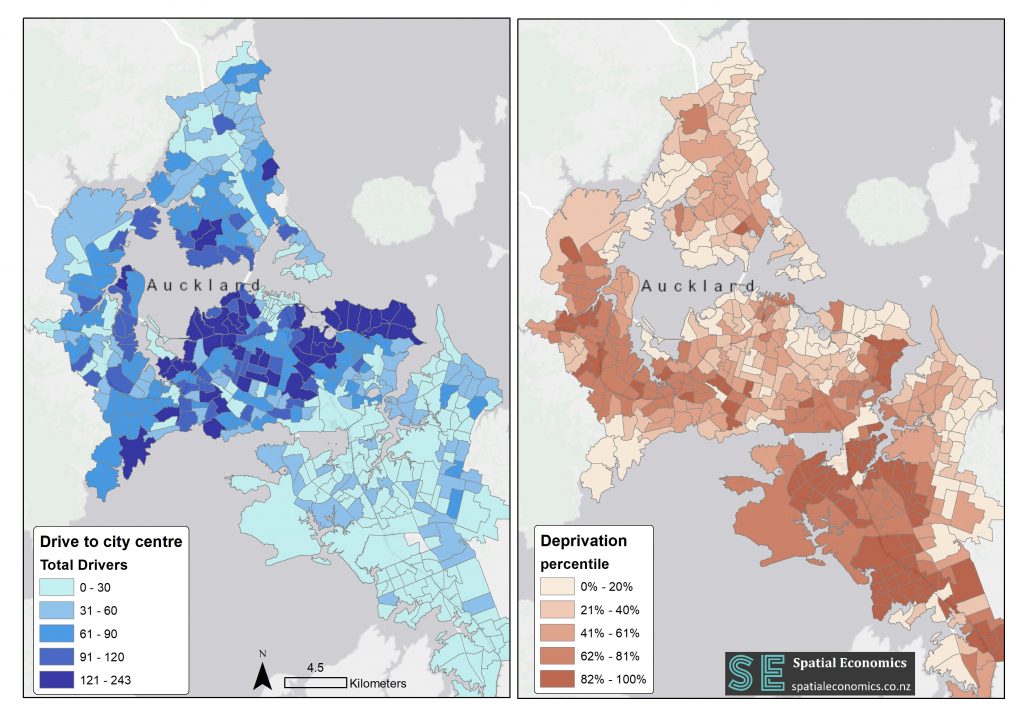
To identify the areas most affected by the road pricing scheme, I employed a bivariate spatial correlation analysis between the number of people commuting by car to the city centre and their deprivation scores. Here’s a detailed breakdown of the process:
- Data Sources: The travel-to-work data was sourced from the New Zealand 2018 Census, while the deprivation data was obtained from the University of Otago’s Socioeconomic Deprivation Indexes.
- Deprivation Percentiles: Instead of using national percentiles, I recalculated deprivation percentiles specifically for Auckland. This approach ensured a more accurate reflection of local socioeconomic conditions.
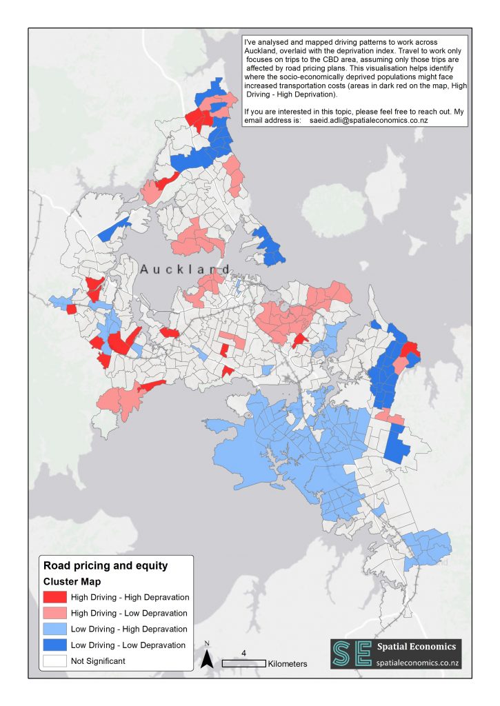
- Mapping: The analysis involved overlaying travel data with deprivation scores using the Bivariate Spatial Correlation method to highlight areas where high car usage coincides with high deprivation levels.
Key Findings
The map reveals significant disparities in how the road pricing scheme impacts different communities:
- West Auckland: Areas in West Auckland, marked in dark red, show a high concentration of low-income individuals who rely on cars to commute to the city centre. These areas are poised to bear the brunt of the scheme’s financial impact.
- South Auckland: Despite lower socioeconomic deciles, South Auckland is less affected due to fewer residents commuting to the city centre by car.
The map underscores the need for a more thorough investigation into the social equity implications of the road pricing scheme. The equity impacts require thorough investigation through the lens of spatial justice, a concept extensively discussed in Edward Soja’s book, Seeking Spatial Justice.
Broader Implications and Recommendations
The road pricing scheme’s equity implications cannot be ignored. Without a deliberate focus on spatial equity, such policies risk disproportionately affecting already disadvantaged communities. While I do not propose specific solutions, it is crucial to:
- Investigate Equity Impacts: Conduct comprehensive studies on the scheme’s social outcomes, ensuring policies are designed to mitigate negative impacts on low-income populations.
- Engage Communities: Include affected communities in the decision-making process to better understand their needs and develop more inclusive solutions.
Conclusion
Auckland Transport’s road pricing scheme, while beneficial in addressing congestion, raises significant equity concerns. Policymakers must balance economic objectives with social justice to ensure fair and inclusive urban development. By considering the spatial justice implications, Auckland can develop a more equitable transport system that benefits all residents.
About the Author
I hold a PhD in social justice and transportation. My doctoral research can be accessed here. If you are interested in this topic and would like more analysis, please feel free to reach out to me at saeid.adli@spatialeconomics.co.nz.
References
Ministry of Transport. (2020). The Congestion Question: Phase One Report.
Soja, E. W. (2010). Seeking Spatial Justice. University of Minnesota Press.
University of Otago. (2018). Socioeconomic Deprivation Indexes: NZDep and NZiDep. Retrieved from https://www.otago.ac.nz/wellington/research/groups/research-groups-in-the-department-of-public-health/hirp/socioeconomic-deprivation-indexes-nzdep-and-nzidep-department-of-public-health.